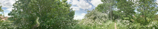
Round the edge
A10 Bund
Photograph copyright S.Bennett
Technical details:
| Date:Spring 2010 | Source:Digital |
| Format:Portrait | Lens:10mm |
| Exposure:3 frames HDR | |
| Images:2 rows of 8 | |
Commentary
The western edge of the village is defined by the A10. The bund is an earth bank raised up and covered with trees to screen the village from the A10. This path leads from Butt Lane to the Sycamores Recreation field. The path amongst the tree is popular with dog walkers, and gives occasional views in either direction.
Compatibility Error: Failed to insert panoramic viewer defaulting to flat image.